3DMakerpro Eagle LiDAR Scanner
Scanner 3D 3DMAKERPRO Eagle LiDAR, Résolution Ultra 8K, Up to 140m de distance, jusqu'à 2cm de précision,...
Scanner 3D 3DMAKERPRO Eagle LiDAR, Résolution Ultra 8K, Up to 140m de distance, jusqu’à 2cm de précision,…
- 8K Ultra Imaging
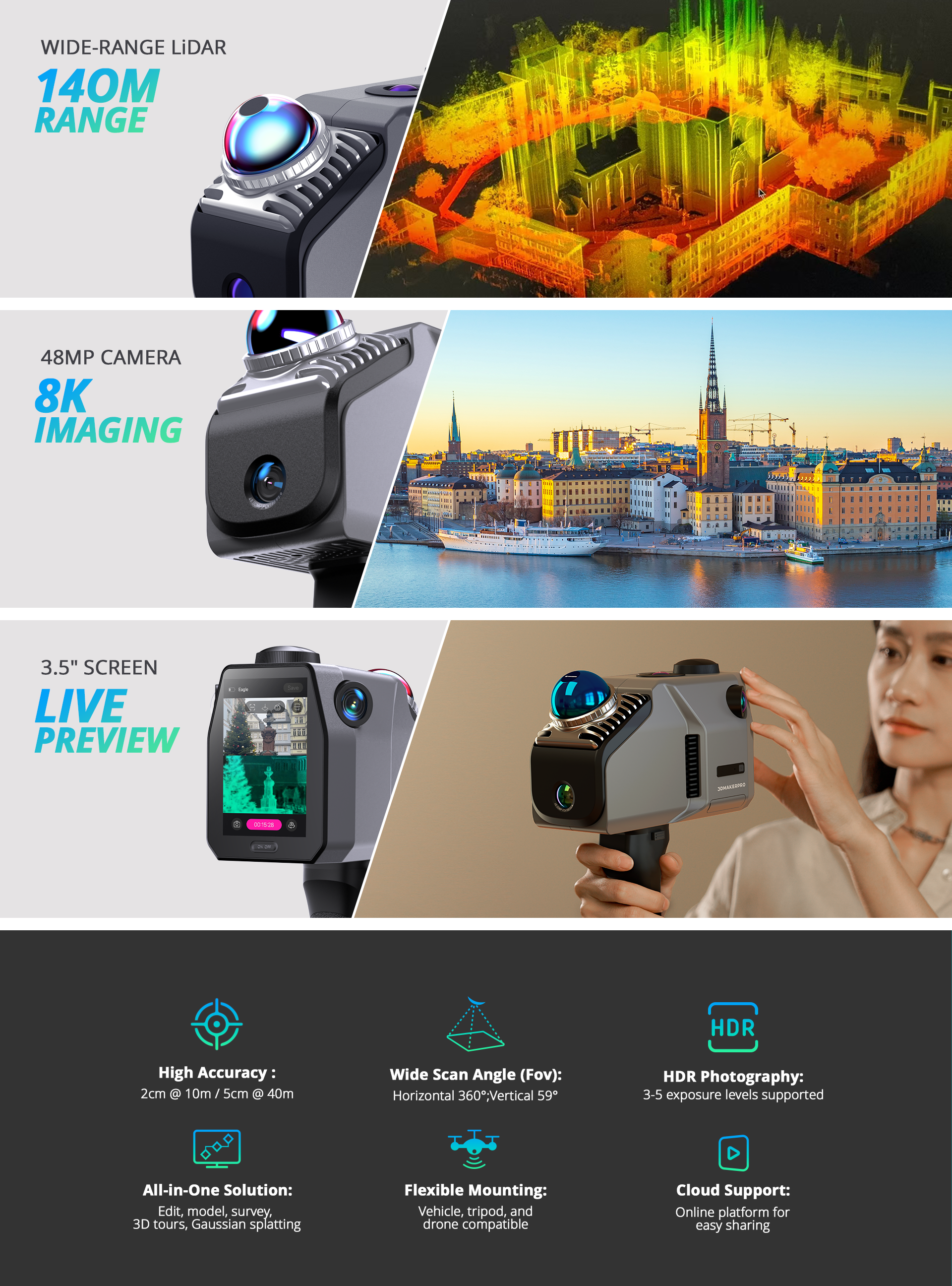
- Up to 140m Scan Range
- Up to 2cm Accuracy
- All-in-one Workflow
Introducing 3DMakerpro Eagle
Eagle is 3DMakerpro’s high-performance spatial scanner, combining high precision, wide coverage, and user-friendly operation. Designed for professionals seeking efficiency and accuracy, Eagle offers an end-to-end solution from data acquisition to 3D production, enabling large-scale 3D scene modeling within minutes. Whether for architectural surveying, film production, or virtual exhibitions, Eagle streamlines the entire process into a one-stop experience.
High-Performance Spatial Scanning
Eagle is equipped with a high-performance LiDAR system, delivering extensive scanning capabilities while ensuring exceptional precision and coverage angles.
70 M
SCANNING RADIUS
Provides a scanning radius of up to 70 meters under 80% reflectivity conditions.
2 CM
ACCURACY
Achieves scanning accuracy of up to 2CM at a 10-meter distance.
High-Precision, Wide-Range Scanning
With a scanning radius of up to 70 meters (80% reflectivity), Eagle efficiently completes precise modeling of large neighborhoods in just a few minutes.
Ultra-Wide Coverage Angle
Eagle’s LiDAR features a field of view of 360°×59°, providing 30% more coverage than standard products on the market. A single, simple rotation is all it takes to fully capture an entire room.
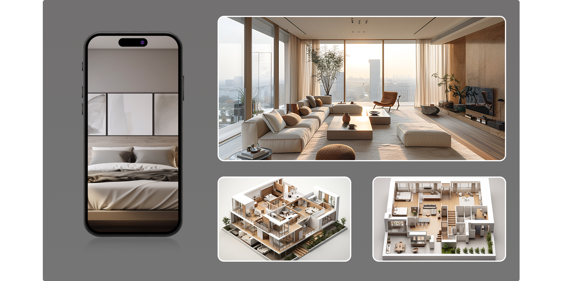
Entering the Era of Colorful Scanning
Eagle comes with up to four 48MP high-resolution cameras, enabling the creation of highly detailed 3D worlds, making it ideal for applications like film production, game development, and virtual exhibitions.
48 MP
CAMERA
Delivers 48MP fisheye detail—4 cameras on MAX, 1 on Standard.
8K HDR
IMAGING
Outputs 8K HDR imaging for vivid colors and dynamic range.
3D Gaussian Splatting
Eagle transforms captured photos into Gaussian distributions to generate highly realistic 3D scenes. The accompanying software creates high-quality Gaussian-Splatting 3D content, compatible with Unreal Engine, allowing for the rapid construction of premium 3D environments.
Immersive Panoramic Tours
Eagle supports pinpoint 8K HDR imaging, delivering stunning light effects and intricate texture details. Create immersive panoramic tours that make your audience feel like they’re truly there.
All-in-one Scanning Solution
Eagle is ready to use right out of the box, allowing users to start scanning immediately. It supports real-time point cloud project browsing and is adaptable for use on various platforms and vehicles.
Ready to Use
No complex calibration is required, saving up to 50% of preparation time compared to traditional devices.
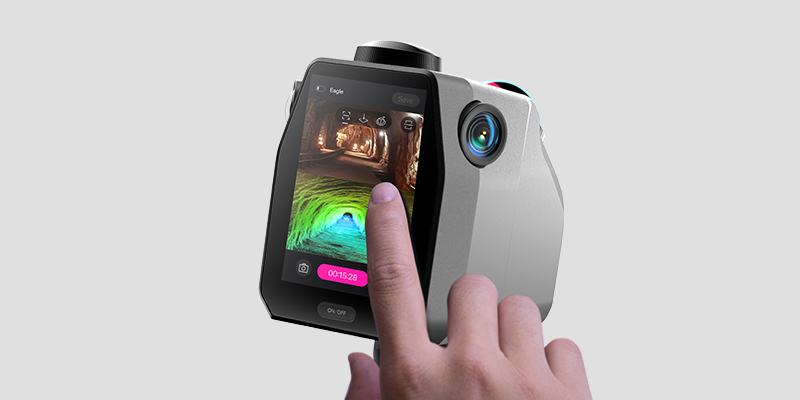
On-Site Review Operations
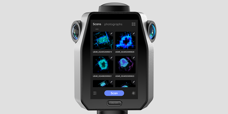
Equipped with a 3.5-inch screen, Eagle offers three real-time display modes during data collection: point cloud, photos, or split-screen point cloud/photos. After collection, users can instantly review point cloud projects, GPS trajectories, and photos.
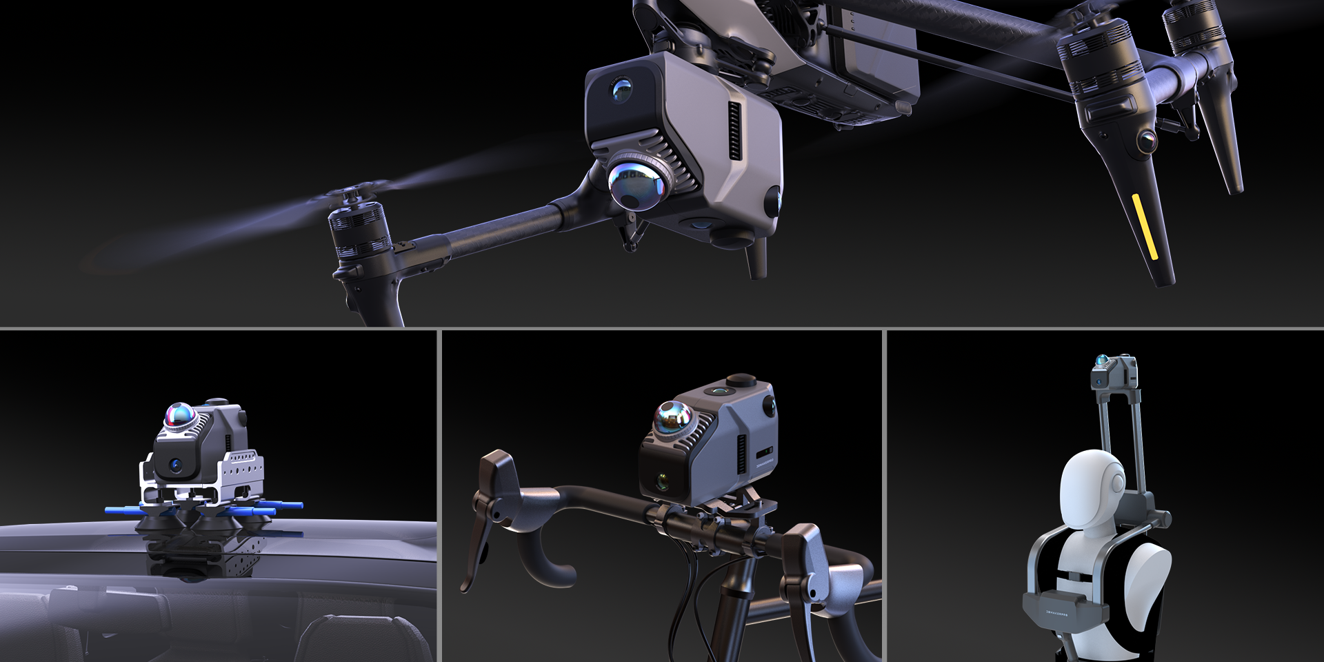
Adaptable to Various Platforms and Vehicles
Eagle collects up to 200,000 points per second, maintaining data quality even at speeds of 20km/h, meeting the needs of dynamic operations across various vehicles.
Platform and Software
Whether it’s architectural surveying, film production, or virtual exhibitions, Eagle’s workflow and companion software ensure a seamless experience from point cloud capture to final presentation.
Launching in March
Host and Showcase Your Creations
JIMUMETA allows you to upload and manage your panoramic tours and Gaussian Splatting projects seamlessly. Enjoy both free and commercial service options.
2 Active Spaces
Price: Free
note: works cannot be shared
10 Active Spaces
Price: $8.99/Month (Introductory Beta Offer)
100 Active Spaces
Price: $80.99/month (Introductory Beta Offer)
Business
Speak with our agent for a customized plan
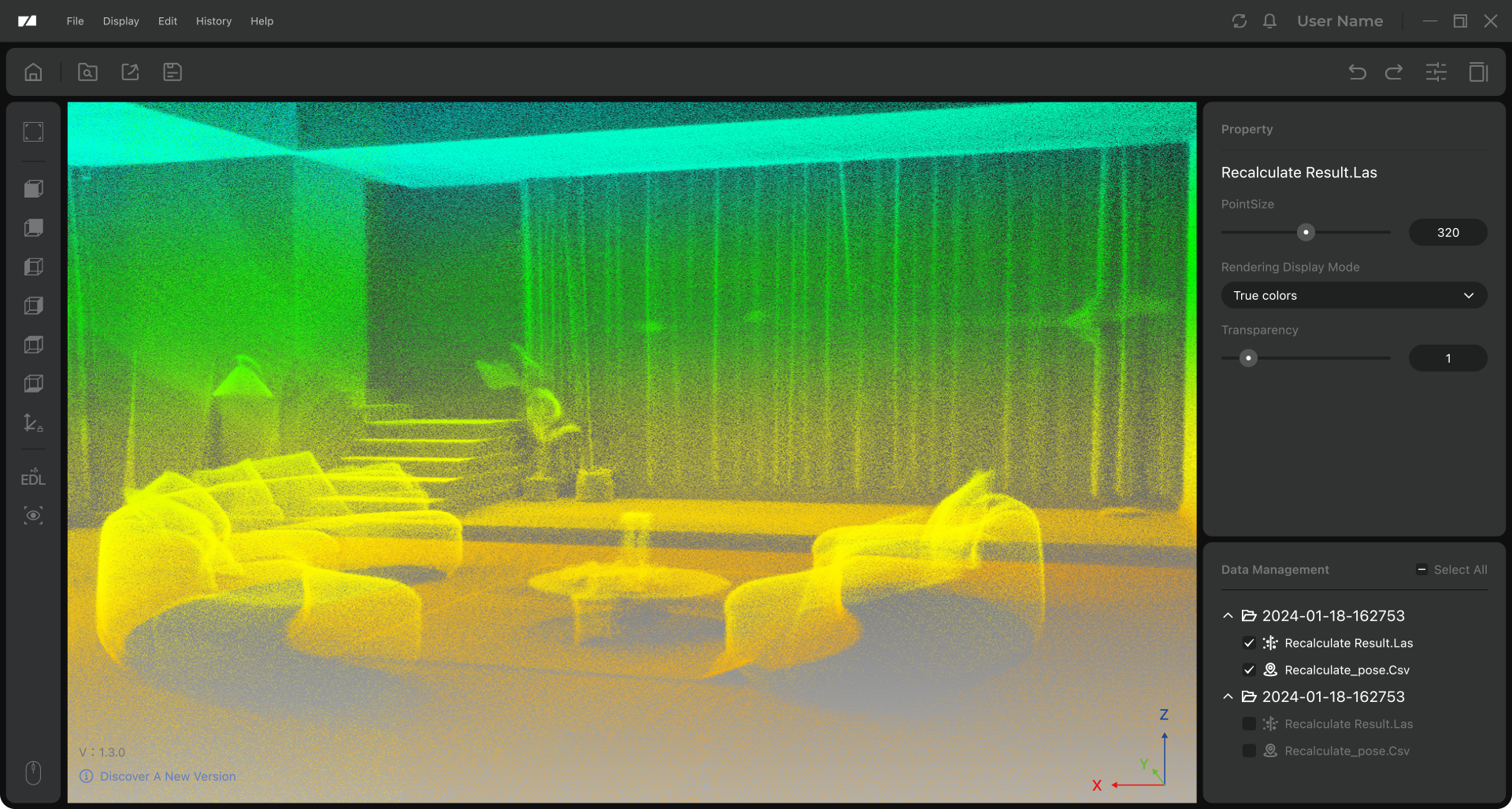
Post-Processing Software
The post-processing software allows users to refine and edit point cloud data, with output formats including PLY, PNG+OBJ, and Gaussian-Splatting PLY (completely free of charge for non-commercial visual sharing), all completely free of charge.
Denoise
One-click noise removal that rapidly clears your point cloud, streamlining your workflow and boosting efficiency.
Optimize
Algorithm-driven point cloud optimization to improve accuracy.